How We Did It
Scarecrow:
|
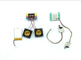
Sound emitting system is assembled with mCookie modules, speakers and batteries. Predatory bird noises are stored in a microSD card which is then mounted onto the system.
|
|
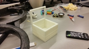
Speaker mount is designed using Autodesk Inventor and 3D-printed.
|
|
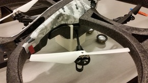
Speaker system is mounted on a Parrot AR 2.0 drone. Sounds to be played are chosen using a remote.
|
Skywatch:
Skywatch is the second step of our Farm Friend program. Safeguarding against pests solves immediate problems, but farmers are still susceptible to natural disasters and weather conditions. As you'll see on our Skywatch page, we've included a live-updating forest fire map to warn farmers about potential forest fires near their tracts of land. We also attempted to use the Planet API and resources, but were unable to due to a problem with the API authorization key. However, if we had successfully downloaded Planet data, we would have used it in the following ways:
Cloud Cover: Using raw data from Planet, we could provide farmers with cloud cover information, which could then be used to tell irrigation systems to raise or lower water supply autonomously.
Sunlight Angle: Again using raw data, we could provide farmers with the relative intensity of sunlight, giving farmers options on which strains of crop they should plant, estimated water to be used, and even if the farm would generate more revenue as a solar farm.
Terrain Type Detection: By scanning a region and taking note of its color, we would be able to tell if it was barren, forested, near water, and more - all important indicators when deciding a location and type for a farm.
